Skip to content
GTA OreVision

Probabilistic mineral mapping · web service

Point to the ground. We map the minerals.

Give us an area — we show you where the minerals are. OreVision turns free satellite and airborne hyperspectral into mineral maps with abundance and a calibrated probability for every mineral, in every pixel.

Priced per km² · NASA EMIT, AVIRIS, EnMAP · invite-only today

GTA · OreVision◇ NASA EMIT
OreVision probabilistic alteration map over a Mongolian copper district from NASA EMIT
TOP TARGET
Argillic–phyllic99.6%
SourceEMIT
EMIT alteration mapping ranked Mongolia open tenders by argillic–phyllic coverage. Source: OreVision tender audit, GTA (2025).
Built on
◇ NASA EMIT ◇ AVIRIS ◇ EnMAP ◇ Tanager 500+ spectra ~130 minerals

How it works

From an area of interest to drill-ready targets

No in-house remote-sensing team required.

01

Send an area

Send an area of interest (or draw one) and choose a target set.

02

We pull the data

We pull free public hyperspectral (NASA EMIT, AVIRIS, EnMAP) and atmospherically correct it.

03

FAST-BMA maps minerals

FAST-BMA™ computes abundance and a calibrated probability for every mineral, in every pixel.

04

You get targets

Interactive maps plus GeoJSON/CSV — drill the targets the data actually supports.

Why OreVision

Every other map gives you a label. OreVision gives you a probability.

Posterior, not a labelCalibrated probability

Abundance AND a calibrated presence probability per mineral, per pixel — not a hard class or a single matched-filter score.

FAST-BMA™Bayesian model averaging

Averages over plausible 1–3-endmember mixtures per pixel instead of forcing one model — honest sub-pixel mineralogy. Patented.

Real uncertainty in the fitRFLUNCERT-weighted

Uses EMIT per-band noise to weight the likelihood; the production chains beat uniform weighting.

NINJA™Detect-then-identify

Background-removed spectrum + ACE + F-test rejects false alarms instead of over-calling. A capability shown in deliverables. Patented.

Multi-sensorOne engine

EMIT (285 bands, 381–2493 nm, ~60 m), AVIRIS (~15 m), EnMAP, ENVI, Tanager. 500+ spectra, ~130 minerals, expandable.

Honest negativesFalse-positive discipline

Minerals that false-positive over a terrain are excluded from rankings. We report where an assumed target is absent.

Powered by FAST-BMA™ NINJA™

Validated in the field

Worked, cited, real

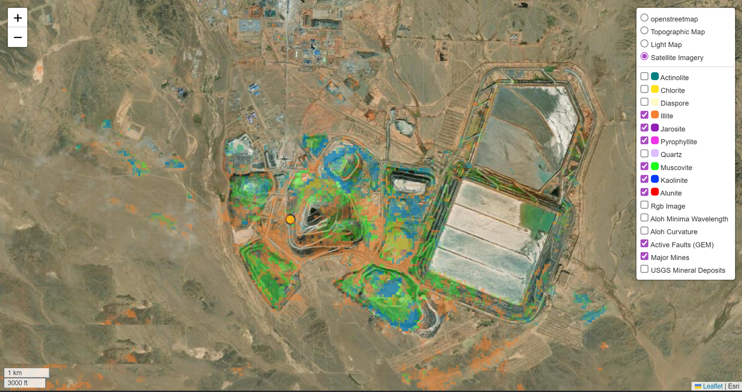
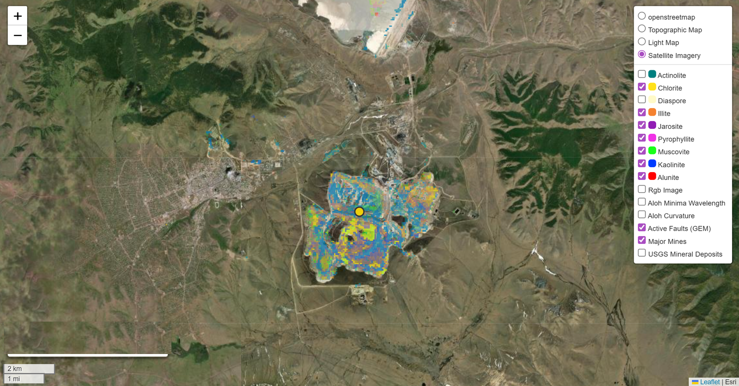
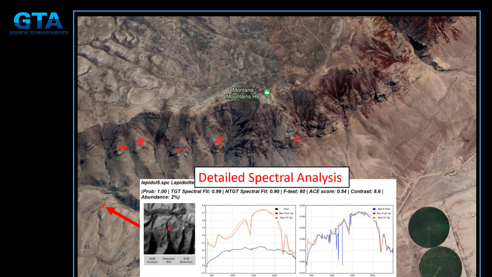
GTA · OreVision + NINJA™ Built

Lepidolite (lithium) at Thacker Pass, NV

Detected AND identified via NINJA™ at 2% abundance (spectral fit 0.99), at the largest measured U.S. lithium resource.

◇ AVIRIS · Thacker Pass
  • Lithium Americas S-K 1300 (2024)
GTA · OreVision Built

Ranking open exploration tenders, Mongolia

EMIT alteration mapping ranked open tenders by argillic–phyllic coverage — top target at 99.6% — and reported honest negatives where an assumed lithocap was absent.

◇ NASA EMIT
  • OreVision tender audit · EMIT L2A · GTA (2025)

Honest build status

What's shipping, what's coming

Built — shipped & validated Building — in active development Planned — on the roadmap
Built

The FAST-BMA engine end-to-end — multi-sensor → abundance+probability → orthorectify → GeoJSON → interactive maps. Validated at Arizona, Cuprite, and Mongolia. The tender-audit product.

Building

The hosted self-serve platform (auth, AOI tool, EMIT scene discovery, credit billing, GPU job queue). Remaining piece: in-platform L1B download + containerized ISOFIT atmospheric correction.

Planned

Fully automated public (non-invite) self-serve.

A targeted map against a multi-million-dollar drill program

Stop drilling blind.

Send us an area of interest and a target set — we'll map it. OreVision is invite-only today; request access below.